The data behind every Sydney fishing decision. Fort Denison tide harmonics and what AHD actually means. The MHL Sydney Waverider buoy and why Hs is only half the story. The BOM Coastal Waters forecast translated into a fishable morning at Hornby versus North Head versus Long Reef. The 3-hour bite window that sits at the end of all of it.
15-minute read · Verified May 2026 · Fort Denison · MHL · BOM NSW04 · 27-feature model
The Friday-night question
Every Sydney rock fisher works backwards from the same Friday-night question. Is the platform fishable tomorrow morning? If not, where is? The data sits across five products — the Fort Denison tide table, the BOM Coastal Waters forecast, the Manly Hydraulics Lab Sydney Waverider buoy, the king-tide entries in the NSW Government adaptation calendar, the solunar table for the local sunrise. Reading any one in isolation gets the answer wrong often enough to ruin a season.
This guide is the working set. It explains what each gauge measures, why two reputable forecasts can disagree by 0.8 metres on the same morning, and how the readings combine into a single GO, HOLD or WAIT verdict. The previous Sydney guides covered where to fish and the legal frame around safety. This one covers the data they reference but do not unpack.
Sydney fishing is two problems that share a postcode. The harbour interior is one. The open coast — every ocean-facing rock platform from Barrenjoey to Cape Solander — is the other. A morning that is unfishable on the coast can be the best window of the month inside the heads.
The harbour bite is driven by tide. Port Jackson is a flooded river valley with a narrow entrance compared to its interior volume, which produces a strong tidal exchange through The Heads twice a day. Flow concentrates bait at points and pylons. The change of state — slack water, the first hour of run-in or run-out — is when most harbour species switch on. Swell is a non-issue. Wave action through the harbour mouth is heavily attenuated by the dogleg between North and South Head; a 3-metre Tasman swell typically registers as gentle wash on Bradleys Head.
The open coast bite is driven by tide too, but the gate that opens or closes the window is swell. A Sydney ocean platform with a 0.8-metre easterly groundswell at 6-second period is calm and fishable. The same platform with a 2.5-metre southerly groundswell at 14-second period is lethal. The bite-window number is irrelevant if a long-period wave will reach the platform. The first thing an open-coast Sydney fisher reads is not the tide table. It is the swell.
That split matters because the forecast products were designed for different audiences. BOM Coastal Waters is written for vessels at sea. Fort Denison is written for harbour pilots. Willyweather and Seabreeze are written for surfers. None is written for a person standing on a sandstone shelf at 5 am. Every Sydney land-based fisher reconciles the inputs by hand or via an app.
Tide — Fort Denison harmonics
Fort Denison is the reference tide gauge for Sydney Harbour and the entire metro coast. The gauge sits on the small island in the middle of the harbour basin. It has been recording continuously since 1886 — one of the longest unbroken tidal records on the eastern seaboard. The harmonic constituents derived from that record are what every Sydney tide table is built on, including the prediction inside Fishare. Botany Bay, the Hawkesbury and Pittwater all reference Fort Denison with a published lag and amplitude adjustment.
AHD versus LAT
Sydney tide tables are usually quoted in metres above Australian Height Datum (AHD), the national vertical reference set to the 1966–68 mean sea level at Fort Denison. A predicted high of 1.65 m AHD means the water surface will sit 1.65 metres above that 1960s mean.
Older tide tables and marine charts use Lowest Astronomical Tide (LAT) instead — the lowest tide level expected over the 18.6-year lunar nodal cycle. For Fort Denison, AHD sits roughly 0.93 m above LAT, so 1.65 m AHD is roughly 2.58 m LAT. Both describe the same water surface but are not interchangeable. When a table quotes a 2.0 m high it almost always means LAT — a moderate spring tide, not a king tide. King-tide values quoted in metres AHD sit between 1.1 m and 1.3 m for Sydney. Knowing which datum is in use prevents the most common Sydney mis-read.
Spring versus neap — the 1.2 m / 0.6 m rule of thumb
Sydney tides are semidiurnal: two highs and two lows per day, roughly six hours apart. The range between highs and lows drives current speed in the harbour and varies on the spring-neap cycle.
Spring tides — within a day or two of new moon and full moon. Sydney spring range typically runs about 1.2 m. Current at the heads can hit 1.5 to 2 knots. The bait flush is at its strongest and pelagic predators key off it.
Neap tides — first and last quarter moon. Sydney neap range typically runs about 0.6 m. Current is roughly half what springs deliver. The harbour bite often goes flat in the middle of a neap unless wind pushes bait into structure.
The harbour guide already references the bite patterns those ranges produce. Run-in dawn for kingfish off Clontarf. Run-out for bream on bridge pylons. High-tide turn for luderick and john dory on harbour reef marks like the Sow and Pigs. Those rules hold across the cycle, with the caveat that on the smallest neaps the change of state is so muted that the bite never really arrives.
King tides — when they fall in Sydney
King tides are the highest predicted astronomical tides of the year. They occur when the sun-moon-earth alignment combines with the perigean phase of the moon's orbit. Sydney peaks cluster around December–January and June–July, with smaller secondary peaks in May and November.
The NSW Government publishes a king-tide calendar through Adapt NSW with the predicted height in metres AHD. A typical Sydney king tide peaks at 1.10 m to 1.25 m AHD; an exceptional event approaches 1.30 m AHD. The June 2022 event reached 1.28 m AHD — high enough to flood low-lying foreshore at Rose Bay and Drummoyne. The fishing relevance is twofold. The harbour bite on a king-tide morning is unusually strong because the flush is at its maximum. The open coast is more dangerous than usual because the elevated water level adds a half-metre on top of the swell wash at every rock platform. A king tide combined with a 2-metre south swell at 12-second period is the classic Sydney rock-fishing fatality combination.
How to read an official tide table versus an in-app prediction
The Bureau of Meteorology publishes Fort Denison high and low times daily. The Manly Hydraulics Lab publishes the same predictions plus the recorded gauge value, which lets you compare prediction against actual. The Fishare in-app prediction derives from the same harmonic constituents. The difference is presentation. A tide table gives four numbers per day. An app gives the water level at every minute and the rate of change in centimetres per hour. For a harbour bream session on a bridge pylon, the rate-of-change number is the useful one — peak bite typically lines up with peak current, the steepest point of the tide curve rather than the high or low itself.
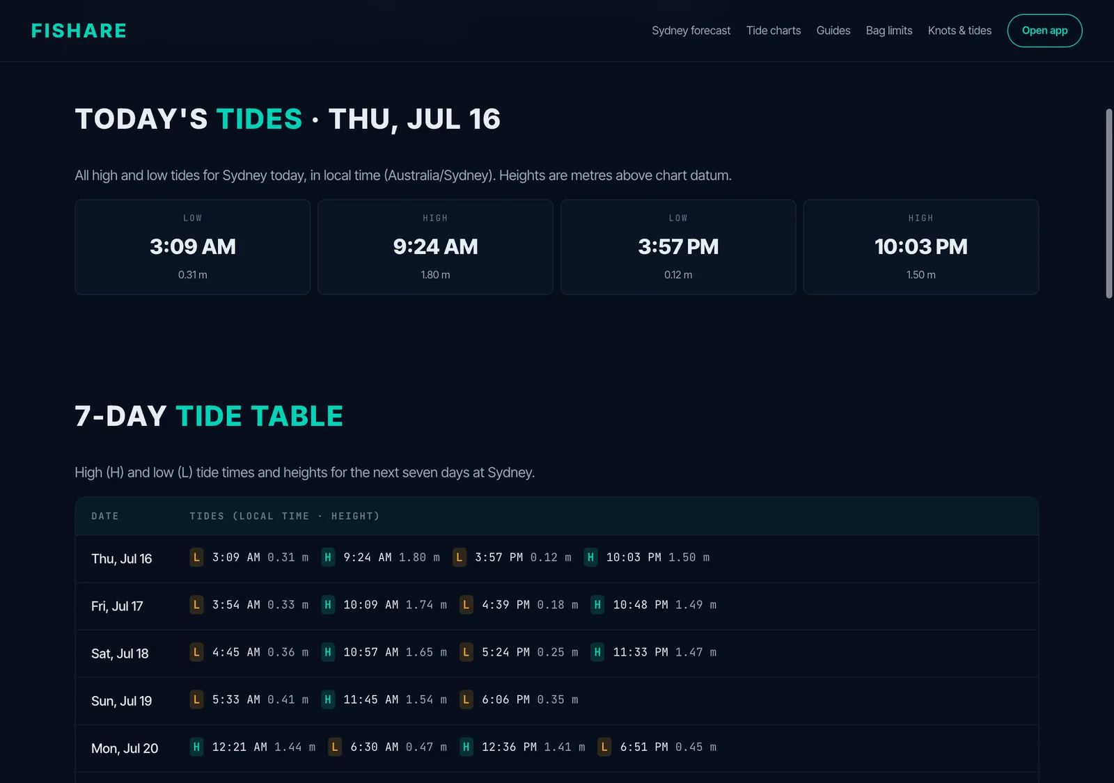
The Sydney tide page — today's four turns plus the week ahead, the raw data behind the mid-tide read.
The reference everyone uses
Fort Denison is the gauge. AHD is the datum. About 1.2 m of range on a spring, about 0.6 m on a neap. King tides peak in the 1.10 m to 1.30 m AHD range a few times each year. Every other Sydney tide reference resolves back.
Swell — the open coast story
The Manly Hydraulics Lab operates the offshore Sydney Waverider buoy roughly 11 kilometres east of Long Reef in approximately 90 metres of water. It transmits significant wave height (Hs), peak wave period (Tp) and peak wave direction every 30 minutes. The buoy is the closest thing Sydney has to ground truth for offshore swell, and every reputable swell forecast is calibrated against its record.
What significant wave height actually means
Significant wave height is not the height of the biggest wave. It is the average height of the largest one-third of waves measured over a 30-minute window. A Hs of 2.0 m means the largest one-third averaged 2.0 metres trough-to-crest. The single largest wave in that window is typically 1.6 to 2.0 times Hs — a 2.0 m forecast carries occasional waves up to 4 metres. A platform that looks safe on the typical wave will be flooded by the once-every-15-minutes outlier.
Period is the variable that kills
The Hs number on its own is not enough. A 1.5 m Hs at 6-second period is wind chop — short, steep, locally generated energy that breaks well offshore. The same 1.5 m Hs at 14-second period is groundswell — long-wavelength energy from a distant storm that carries vastly more water per wave and runs up the platform much higher.
The Sydney rule of thumb is that period above 10 seconds requires a re-think of any platform choice. Above 12 seconds, anything south-facing on the open coast is marginal. Above 14 seconds the open coast is generally off the table and the only fishable rock water sits well inside the heads. Those are operational thresholds rather than legal definitions. The lifejacket law applies regardless of swell.
Direction is the variable everyone forgets
Sydney's coast faces broadly east. A pure easterly groundswell hits every headland symmetrically. A south-southeast swell — the most common Sydney winter pattern — wraps differently around the heads depending on local geometry. North Head's eastern face is partially sheltered from due-south swell by the headland itself, while Long Reef catches the full wrap. South Head's Tasman face takes a southerly swell fully; Hornby Lighthouse and Gap Bluff are among the first to be unfishable when a buster pushes swell up to the coast.
Refraction at the heads also matters. The same offshore 2.0 m southerly arrives at the Fairfax-accessible ledges below North Head differently than at the Gap. Local bathymetry concentrates wave energy in some positions and dissipates it in others. That is why an experienced Sydney rock fisher can call a 1.8 m swell as "fishable at Long Reef, dangerous at Hornby" on the same morning, while the BOM forecast is identical for both.
Southerly buster versus easterly groundswell
The two common Sydney swell events have different fingerprints.
Southerly buster. A front pushes up from the Tasman, often arriving in the afternoon. Wind clocks abruptly from north-east to south. Wave height climbs quickly — a calm 0.8 m can become 2.5 m within four hours. Period is initially short (6 to 8 seconds) and lengthens over 24 to 36 hours as a longer fetch establishes. Open-coast platforms fishable before lunch are unfishable by sundown.
Easterly groundswell. A distant Pacific storm sends long-period waves into the Sydney coast over several days. Hs may be modest (1.5 to 2.0 m) but period is long (12 to 16 seconds). East-facing rocks catch the full energy. South-facing rocks are partially sheltered by orientation. Refraction at the heads is more pronounced because the wavelength is longer.
Wind-driven buster swell is well captured by every standard model. Easterly groundswell is harder — the source is often far offshore and propagation models disagree. That is why the morning-of MHL reading matters.
The forecast stack — what to read in what order
Five products carry most of the working weight for Sydney land-based fishing decisions. They are read in a particular order, with each later product checked against the earlier one.
1. BOM Coastal Waters Forecast — NSW04 Sydney
The Bureau of Meteorology Coastal Waters Forecast covers the strip of ocean from Broken Bay to Port Hacking out to roughly 60 nautical miles. It is published twice daily — the morning issue around 5 am, the afternoon issue around 4 pm — and pushed via the standard BOM API endpoints. It covers wind, sea state and swell plus a written outlook. Read the swell direction and height for the morning you want to fish, plus the wind for the same window.
2. MHL Sydney Waverider buoy — real-time reality check
The MHL data portal publishes the buoy reading at half-hour resolution. On the morning of the session, the buoy is ground truth. A BOM forecast of 1.5 m at 10 seconds that translates to an MHL reading of 2.4 m at 13 seconds at dawn is a forecast bust — the session is off. The reverse is a green light.
3. Willyweather and Seabreeze — hourly granularity
Both services present at hourly resolution rather than the BOM's six-hour blocks. They are useful for spotting the inside of a swell window. A pattern like 2.2 m at 7 am dropping to 1.4 m by 11 am is visible in Willyweather but averaged out of the BOM block forecast. The two services often disagree by 0.3 to 0.6 m on the headline number for the same hour. Both are calibrated against the same MHL buoy, so the disagreement is usually about model handling of a transition.
4. Magicseaweed — swell-direction visualisation
Magicseaweed (Surfline since the acquisition) is built for surfers but reads cleanly for rock fishers. Its strength is the direction arrow and the multi-component breakdown — primary and secondary swells are listed separately rather than collapsed into a single Hs. A 1.8 m primary at 11 seconds from 180 degrees plus a 0.7 m secondary at 14 seconds from 110 degrees describes a different sea state than a single 2.0 m reading would suggest. That second swell is often the one that washes a platform an hour earlier than expected.
5. Open-Meteo marine API — the data Fishare uses
Open-Meteo is the marine weather API that Fishare reads from. It bundles wave height, swell height (separated from wind sea), wave period and direction, sea surface temperature and ocean current at hourly resolution out to seven days. The Sydney-coast numbers are derived from the European ECMWF wave model rather than the BOM's local model. The two agree well on most days and diverge most on rapid-transition events. The 27 features in the bite-window model are built from this dataset, which is why bite scores update at the same pace as Open-Meteo refreshes — typically every 3 hours.
When they disagree
The standard reconciliation is BOM for the official outlook, MHL for the current state of the sea, the higher-resolution products for hourly timing inside the BOM window. If the four agree, the answer is the answer. If they disagree by more than 0.5 m on the headline number or by more than 3 seconds on period, the conservative read is correct. Local conditions on the morning override everything. The final call is made standing on the rocks, not at the kitchen table.
Wind direction matters more than wind speed
A 20-knot wind from the wrong direction makes a platform unfishable that would be fine in 30 knots from the right direction.
Northerly. Onshore at most south-facing rocks (Maroubra, Cape Banks, Little Bay). Offshore at most north-facing platforms. The classic Sydney summer pattern is a light north-easterly building through the day, often switching to a southerly buster in the late afternoon.
Easterly. Onshore everywhere on the open coast. Pushes harbour swell up Port Jackson — even the inner-harbour foreshore at Bradleys Head picks up wash on a strong easterly. The least friendly wind for Sydney rock fishing.
Southerly. The fishery-defining wind. Brings the swell that defines the buster cycle. Offshore at the north-facing platforms. Onshore at every south-facing rock. Wind-against-tide on the run-in at the heads produces steep chop on top of the swell.
Westerly. Offshore at the entire Sydney open coast. Flattens chop and often makes a difficult forecast fishable. A westerly morning is the working land-based fisher's signal that the platform is on.
The post-frontal clearing window
A typical southerly buster cycle peaks over 12 to 24 hours and clears. Wind backs from south into the west. Swell takes longer to drop — energy in the water lags wind by 18 to 36 hours. The fishable window is when wind has cleared into the west but the swell is still up. Most coastal points fish poorly during that window. Platforms with sheltered geometry — Long Reef's north face, the lee side of Bradleys Head, the Clontarf shoreline — fish very well. Bait pushed deep by the front comes back up the column.
Wind-against-tide chop
Wind against tidal flow steepens the wave face. The punishing example is a southerly on the run-in at the heads — wind pushes water out, tide pushes water in, the resulting chop stacks. A 1.5 m offshore swell can break as a 2-metre standing wave through the heads. Harbour flats are unaffected. The shore-of-the-heads rock platforms are where it bites.
Sun, moon, light — solunar windows
The bite weight on the first and last hour of daylight is the most consistent pattern in the Sydney inshore catch record. Tide and pressure modulate it. Moon phase modulates it less than the fishing magazines suggest.
Civil twilight versus sunrise
Civil twilight in Sydney begins about 25 minutes before sunrise — the first usable light on a clear morning. The bite often switches on at civil twilight rather than at sunrise itself. Astronomical dawn (about 90 minutes before sunrise) is too dark to fish but is when bait species like yellowtail stage near the surface. On a clear winter morning at Hornby, the standard rhythm is metals from civil twilight to about 30 minutes after sunrise, then the bite drops off through the middle of the day.
New moon, full moon — and what Sydney catch data actually shows
Solunar tables sold in tackle shops attribute most variation in bite quality to moon phase. The Sydney inshore catch record is more nuanced. Two patterns hold up against the data.
Warm-summer mulloway — Hawkesbury and Botany Bay catches concentrate around the new moon. The dark phase appears to favour mulloway hunting in deep holes. The full moon is quiet for trophy mulloway in Sydney waters.
Harbour bream — neither moon phase is consistently dominant. Bridge pylon and breakwall catches distribute across the lunar month, with the dominant variable being tide state at dawn or dusk rather than moon phase.
The moon-table reputation is overstated for Sydney inshore fishing. Published solunar windows correlate weakly with bite quality once tide and time-of-day are controlled for. The exception is the new-moon mulloway pattern, which is robust enough to plan a session around.
How the Fishare model handles solunar
The 27-feature model includes solunar as one input among many. It nudges a dawn score upward against a midday score under otherwise identical conditions but does not override a strong tide or pressure signal. A clean run-in tide at lunchtime on a falling barometer will outscore a slack-water dawn under most parameter combinations.
The Fishare 3-hour window — what we do
Fishare's bite-window model reads the marine and weather feed from Open-Meteo every three hours and scores each hour of the next seven days for a saved spot. The score is 0 to 100. The model accepts 27 features per hour — wave and swell metrics, wind, sea surface temperature, ocean current, air pressure and tendency, cloud cover, rainfall, tidal state and rate of change, solunar proximity, moon phase, season encoding, region indicators and a storm-severity composite. It is a small neural network trained on a catch dataset.
Inshore mode versus offshore mode
The same model runs in two configurations.
Inshore — default for harbour and shore-based fishing. Tide weight is high. Swell weight is moderate. SST weight is low. The classic Sydney harbour bream window at the bottom of the run-in tide at dawn is the canonical inshore pattern.
Offshore — for wide-water and current-edge fishing on the East Australian Current. SST weight is high. Current speed and direction consistency are weighted heavily. Tide weight is low.
The access score is separate from the bite score
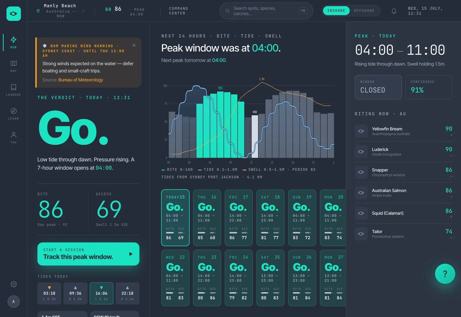
A high bite score does not mean the platform is safe to fish. The model produces two outputs — a bite score (probability the fish are active) and a fishability score (probability the conditions allow casting and landing fish). For an exposed rock platform, the fishability score weights swell height and period heavily. A bite of 85 paired with an access of 30 is a warning, not a green light. Sydney rock fishers see this most often on a falling southerly: the fish are switching on in the post-frontal water, but the swell that produced the front is still washing the platform. The daily verdict is GO only when both clear their thresholds — bite at 70 and access at 50. Below that the verdict is HOLD. Below 50 on bite it is WAIT.
The verdict this section describes — a bite score and a separate access score resolved into a single GO, HOLD or WAIT.
How to read the matrix view
The matrix view shows a 14-day window vertically and saved spots horizontally, colour-coded by day verdict. The pattern most weeks is one or two clear green days for the harbour spots and a different day green for the open-coast spots — the inverse relationship between tide-driven and swell-driven fishing reflected in the calendar.
Try the Sydney forecast page
/forecast/sydney/ pulls the 27-feature model and overlays BOM, Fort Denison tide times and the MHL buoy. Save the spots you fish and the matrix fills in for 14 days.
A worked example — Saturday morning, North Head Fairfax
Saturday 23 May 2026. A Sydney rock fisher wants to fish the Fairfax-accessible ledges below North Head from civil twilight. The brief is metals for tailor and salmon, with a longshot at a winter kingfish off the deep edge. The decision is made on the Friday night.
Step 1 — BOM Coastal Waters NSW04
The Friday evening forecast reads: wind south-west 10 to 15 knots, becoming west to south-west 15 to 20 knots in the morning. Sea below half a metre. Swell south-southeast 1.5 to 2.0 metres. Wind is offshore at North Head's east-facing platform — metals will cast well. The sea is small. The swell is the variable to drill into.
Step 2 — MHL Sydney Waverider buoy
The Friday 8 pm MHL reading is Hs 1.7 m at peak period 11.5 seconds from 170 degrees. Forecast and buoy agree. The period is at the threshold of comfortable — 11.5 seconds is groundswell territory and the south-southeast direction is the awkward one for North Head's eastern face. It is not 14-second water and Hs is under 2 m, so the platform is not categorically off.
Step 3 — Willyweather hourly
Willyweather shows the swell easing through the morning — 1.7 m at 4 am, 1.5 m at 7 am, 1.3 m by 10 am. Period drops from 11 seconds at dawn to 10 seconds by mid-morning. The window improves through the morning, in line with the BOM "easing in the afternoon" wording.
Step 4 — King-tide and solunar check
The NSW Government king-tide calendar shows no flagged event for 23 May 2026. The Saturday high at Fort Denison is predicted at 1.45 m AHD at 09:18, the low at 0.42 m AHD at 03:08 — a moderate spring tide two days past new moon. No king-tide premium on the swell wash. Sydney civil twilight is approximately 06:32; sunrise 06:55. The combination of dawn light and a rising tide puts the strongest bite signal at 06:30 to 09:00.
Step 5 — Fishare bite score
The Sydney forecast page for the saved North Head Fairfax spot shows a bite score of 68 for the 06:00 to 09:00 window and an access score of 55. The numbers are consistent with the inputs — moderate spring tide running in on a dawn window, offshore wind, swell at the upper end of the comfortable range. The verdict is HOLD rather than GO. The bite score is one step below the GO threshold and the access score is the binding constraint.
The verdict
The honest read is HOLD with bias toward GO if Saturday morning comes in better than forecast. The session is worth driving to the carpark for. Walk the Fairfax track at 05:45, watch the swell for 30 minutes from the lookout, and make the final call on the rocks. If the buoy reads under 1.5 m at 06:00, the platform is fishable. If it has held at 1.7 m at 11.5 seconds, fish higher on the platform than usual. If a set washes the access position before you have set up, walk back. The forecast tells you the field. The platform tells you the answer.
Olli-Mikael Vaittinen has fished his whole life. Fifteen years of fly fishing, guiding seasons on Norway's Lakselva — his favourite Atlantic salmon river — and a blue marlin landed in Vava'u, Tonga. Founder of Fishare — the app that puts the data behind the decisions every angler makes on the water.
The Sydney forecast page pulls the 27-feature bite model, the BOM Coastal Waters outlook, Fort Denison tide times and the MHL buoy reading into one view. Save the platforms you fish and the matrix fills in for the next 14 days.
Sydney Harbour Fishing — The Complete Guide — the flagship companion piece. Spot-by-spot rundown of every fishable corner of Port Jackson, including the tide patterns the harbour section above references.
Sydney Aquatic Reserves — A Field Guide — every NSW DPI aquatic reserve in the Sydney metro with verbatim rule text. Read alongside this guide for the legal frame around each platform.
Sydney 7-day forecast — the live 3-hour bite window at your saved water, the BOM overlay and the MHL buoy reading.
Sources cited
Every regulatory and data claim in this guide traces to a source below. Fort Denison harmonic constants, the MHL Waverider buoy specifications and the BOM Coastal Waters NSW04 product definitions are reviewed annually by the respective agencies. Local platform behaviour is informed by long-standing Sydney rock-fishing practice rather than published documents — those statements are flagged in the text as rules of thumb.
Last verified: 2026-05-20. Tide and swell data are forecast products and carry inherent uncertainty. The MHL Sydney Waverider buoy reading is the most reliable real-time reference for offshore conditions. The final fishability decision is made on the rocks, not at the kitchen table — and the lifejacket law applies regardless of forecast.