READING THE WATER — FINDING BLUEFIN IN UK SEAS WITH SST AND HABITAT MAPS
Bluefin are back in the Celtic Sea and the Western Approaches, but the ocean is vast and a boat covers very little of it. Here is how daily sea-surface-temperature fronts and a habitat-suitability index turn a 10,000 km² search into a short list of marks actually worth the fuel.
8-minute read · Updated June 2026 · SST · fronts · habitat (HSI) · Celtic Sea & Western Approaches
Atlantic bluefin tuna are back off the south-west. After decades away they are a fixture again in the Celtic Sea and the Western Approaches, and for the recreational angler that has gone from rumour to reality: England's catch-and-release recreational fishery — the Marine Management Organisation's CRRF — runs again in 2026, open mid-July to 30 November, with around 150 permitted vessels, mandatory Angling Trust training and a strong fish-welfare focus.
The fish are here. The hard part isn't the fight — it's finding them in the first place.
Bluefin are nomads. They follow bait across the shelf edge and through the Celtic Sea, covering tens of miles a day, and they don't leave a forwarding address. On a typical trip you might run two or three hours offshore, and even a fast boat working hard only sees a sliver of water in a day. Burn the wrong tank of diesel on the wrong patch of ocean and a precious weather window is gone.
Commercial fleets solved this problem decades ago by reading the ocean from space before they ever left the harbour. That same information is now free, daily, and pointed straight at our waters. Two layers do most of the work: sea-surface temperature (SST) and a habitat suitability index (HSI).
SST: it's the edges, not the number
Sea-surface temperature is exactly what it sounds like — how warm the top of the ocean is, measured by satellite across the whole sea at once. In our waters bluefin feed comfortably across a broad band of surface temperatures, very roughly the mid-teens to around 20°C through late summer and autumn. But the single most useful thing on an SST map isn't the temperature itself.
It's the edges.
Where two bodies of water with different temperatures meet, you get a front — a line where the temperature changes sharply over a short distance. Fronts are the ocean's hedgerows. Lighter, warmer water meets denser, cooler, nutrient-rich water; the mixing fuels plankton; plankton feeds the baitfish — mackerel, scad, sardine, sprat; and the bait stacks up along that seam in tight, nervous schools. Bluefin know this. They patrol the warm side of a front the way a hawk works a field margin.
In the Western Approaches the fronts that matter are the shelf-break front, where the relatively shallow continental shelf drops away into deep Atlantic water, and the tidal-mixing fronts that set up across the Celtic Sea through the warmer months, separating stratified offshore water from tidally-churned coastal water. On a good SST map these show up as a tight crowd of colour bands. The closer the bands, the stronger the front — and the more reason to look there. A flat, even wash of colour, however perfect the temperature, is just water.
The one-line version
The temperature number puts you in the area. The temperature edge holds the fish. Fish the seam between two water masses — not the middle of a big, even patch.
HSI: every clue stacked on one map
SST is powerful, but it's one layer, and it has a real-world problem: cloud. A band of weather can blank out the very patch of sea you wanted to read, right when you need it. SST also can't, on its own, tell you whether a front is actually productive or just a temperature line over a desert.
That's what the Habitat Suitability Index is for. HSI doesn't replace SST — it fuses it with everything else the satellites saw and boils the lot down to a single, plain-language score for every patch of sea: given today's conditions, how bluefin-like is this water, from 0 to 1?
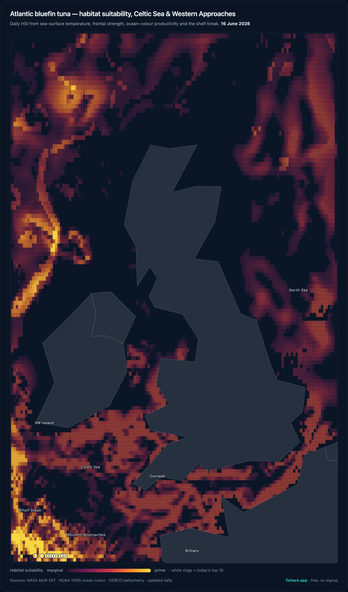
Fishare's live bluefin habitat (HSI) layer for UK & Irish waters, 16 June 2026. Brightest = most suitable; the strongest water runs along the shelf edge off the Western Approaches and south-west Ireland. White rings mark the day's top-10 cells.
Under the bonnet it's weighing up several independent signals:
Temperature
Is the water in the band bluefin actually use here?
Frontal strength
How sharp is the SST gradient? The front-finder doing the maths so you don't have to squint at colour bands.
Productivity
Ocean-colour data reveals chlorophyll — the green signature of the plankton blooms at the bottom of the food chain that ends in tuna.
Seabed structure
Is there a shelf break or drop-off forcing nutrient-rich water up toward the surface?
Any one of those can lie to you. Stacked together, they tell a much more honest story — and where cloud knocks out one input, the others keep the picture alive. The result is a map you can read at a glance: the brightest zones are where the temperature, the fronts, the food and the structure all line up at once.
One honest note on the UK map
In some regions the model also reads current and eddy edges from satellite altimetry — the swirls that trap bait off a western-boundary current like the East Australian Current or the Gulf Stream. UK shelf seas don't work that way: the productive features here are the shelf break and the strong tidal-mixing fronts, so that's what the bluefin map leans on. It's a deliberately honest model of these waters, not a generic one bolted on.
Using it on the day
None of this is meant to fish for you. It's meant to point you. A simple routine:
The night before, or the morning of, pull up the latest map and look at your reachable water — what's actually within range given fuel and the forecast.
Find where a strong front and a high-HSI zone overlap. That overlap — not the warmest water and not the greenest water on its own — is your starting mark.
Plan the run to work that seam rather than a single point. Fronts are lines, so troll or watch along them.
Then trust your eyes. Birds working, bait flicking, marks on the sounder, a fizz of activity on the surface — the ocean gets the final vote. The map just makes sure you're parked in the right postcode to read those signs at all.
Used this way, a daily map quietly turns a blind offshore gamble into an informed decision. It won't put a fish on the trace, but it stacks the odds, trip after trip — and over a season that's the difference between searching and fishing.
Why this matters for the Western Approaches
This is exactly the kind of water where the maps earn their keep. Runs from Cornwall, the Isles of Scilly, Pembrokeshire and the south of Ireland are long and the fuel is dear. The season is a handful of weather windows between July and November, not an open-ended summer. And it's a catch-and-release fishery: the faster a crew finds fish, the less time the boat spends grinding around searching, and the more of the day is spent fishing cleanly and getting tuna back in good condition.
Spending less effort to find fish isn't just cheaper — it's better for the fish, and better for the science the fishery is built on. Less searching means less fuel, fewer hours of disturbance, and tuna that come to the boat fresher and go back stronger.
Where the numbers come from
Credibility matters, so it's worth being clear about the sources. The maps are built from the same science-grade, openly published satellite feeds that oceanographers and fisheries researchers use — not a black box:
Sea-surface temperature — NASA's MUR analysis (gap-filled to roughly 1 km, so cloud doesn't leave holes), distributed through NOAA CoastWatch.
Ocean-colour / chlorophyll — NOAA CoastWatch VIIRS, the productivity signal behind the front.
Seabed & shelf break — GEBCO global bathymetry, so the model knows where the shelf drops away.
Updated daily, focused on the Celtic Sea and Western Approaches, free, and no signup. That last part is deliberate. The fishery is opening up to a new generation of anglers, and the oceanography that gives the commercial fleets an edge shouldn't be locked behind a subscription. If it helps more people find fish faster — and handle them better — that's the point.
A starting point, not a silver bullet
Bluefin will always do bluefin things. They move, they sound, they show up exactly where the map said they shouldn't and ignore the perfect-looking front next door. No satellite can change that. What a good SST-and-HSI map can do is make sure that when you commit fuel and a weather window, you're committing them to the best water you could have picked — and then it's down to you, your crew and your watercraft.
Try it for your next trip
The live bluefin map for the Celtic Sea and Western Approaches is free at fishare.app — updated daily, no signup. If you're fishing the 2026 CRRF season, I'd genuinely like your feedback on how it reads against what you find on the water.
Olli-Mikael Vaittinen has fished his whole life. Fifteen years of fly fishing, guiding seasons on Norway's Lakselva — his favourite Atlantic salmon river — and a blue marlin landed in Vava'u, Tonga. Founder of Fishare — the app that puts the data behind the decisions every angler makes on the water.
Fishare puts sea-surface temperature, the front-strength layer, chlorophyll and a species-by-species habitat heatmap on one map, with a 14-day slider so you can watch a front set up before you run. Atlantic bluefin habitat is live for the UK and Ireland. Free to view, no account needed to browse.
How to Read SST and HSI Maps — the full mechanics: why the edge beats the average, how the gradient layer draws fronts for you, and the pre-trip workflow, with worked examples.
Open the Fishare map — pan to the Celtic Sea and Western Approaches and the bluefin habitat overlay shows that water's conditions. Free to browse.
Sources cited
The data layers described in this guide are built from public oceanographic products. The "fish the front" principle and bluefin thermal preferences are well established in fisheries oceanography; the 2026 fishery rules are from the UK Government / Marine Management Organisation.
Last verified: 2026-06-17. SST, front and habitat layers are model and remote-sensing products and carry inherent uncertainty. A habitat-suitability map shows where conditions are favourable, not where fish are present — treat a hotspot as the best place to start looking, and always fish within the rules of the 2026 CRRF and current UK regulations.